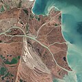
Fil:Danubedelta chilia lobe satellite image.jpg

Størrelse af denne forhåndsvisning: 600 × 600 pixels. Andre opløsninger: 240 × 240 pixels | 480 × 480 pixels | 768 × 768 pixels | 1.024 × 1.024 pixels | 2.048 × 2.048 pixels | 3.679 × 3.679 pixels.
Fuld opløsning (3.679 × 3.679 billedpunkter, filstørrelse: 3,95 MB, MIME-type: image/jpeg)
Filhistorik
Klik på en dato/tid for at se filen som den så ud på det tidspunkt.
| Dato/tid | Miniaturebillede | Dimensioner | Bruger | Kommentar | |
|---|---|---|---|---|---|
| nuværende | 5. jul. 2014, 00:10 |  | 3.679 × 3.679 (3,95 MB) | Gretarsson | {{Information |Description ={{en|1=Original image caption (excerpt): The image above was acquired on February 5, 2013, by the Advanced Land Imager (ALI) on NASA’s Earth Observing-1 (EO-1) satellite. The Danube Delta has a number of lobes formed ov... |
Filanvendelse
Den følgende side bruger denne fil:
Global filanvendelse
Følgende andre wikier anvender denne fil:
- Anvendelser på cy.wikipedia.org
- Anvendelser på de.wikipedia.org
- Anvendelser på fa.wikipedia.org
- Anvendelser på fi.wikipedia.org
- Anvendelser på ja.wikipedia.org
- Anvendelser på mk.wikipedia.org
- Anvendelser på ru.wikipedia.org
- Anvendelser på sl.wikipedia.org
- Anvendelser på ta.wikipedia.org
- Anvendelser på th.wikipedia.org
- Anvendelser på uk.wikipedia.org
- Anvendelser på vi.wikipedia.org


