
Fil:Fukushima I NPP 1975 medium crop rotated labeled.jpg

Størrelse af denne forhåndsvisning: 300 × 600 pixels. Andre opløsninger: 120 × 240 pixels | 240 × 480 pixels.
Fuld opløsning (800 × 1.600 billedpunkter, filstørrelse: 248 KB, MIME-type: image/jpeg)
|
|
Denne fil er fra Wikimedia Commons. Beskrivelsen af filen fra Commons er gengivet nedenfor. |
Beskrivelse
| Beskrivelse |
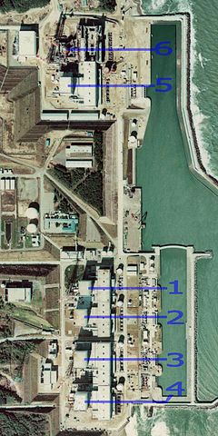
English: Fukushima I Nuclear Power Plant. Medium crop showing reactors labeled 1 to 5 and site for reactor 6. North is up.
日本語: 福島第一原子力発電所。 |
| Dato | |
| Kilde | http://w3land.mlit.go.jp/cgi-bin/WebGIS2/WC_AirPhoto.cgi?IT=p&DT=n&PFN=CTO-75-30&PCN=C29B&IDX=21 |
| Forfatter | Ministry of Land, Infrastructure, Transport and Tourism |
| Andre versioner |
|
| Kameraposition | | Dette og andre billeder på deres position på: OpenStreetMap |
|---|
Licensering

|
Indehaveren af ophavsretten til denne fil, the Ministry of Land, Infrastructure, Transport and Tourism of Japan, tillader enhver at bruge filen til ethvert formål, under betingelse af, at rettighedshaveren krediteres som påkrævet. Videredistribution, afledte værker, kommerciel brug og alle andre formål tillades. |
Kreditering:
Copyright © National Land Image Information (Color Aerial Photographs), Ministry of Land, Infrastructure, Transport and Tourism
|
 |
This image is copyrighted by the Ministry of Land, Infrastructure, Transport and Tourism of Japan. For terms of use, see the stipulation to use of National Land Information (in Japanese) and message from MLIT (in Japanese and English). When you display this image on an article, include the following phrase in the description: "Made based on National Land Image Information (Color Aerial Photographs), Ministry of Land, Infrastructure, Transport and Tourism".
|
Filhistorik
Klik på en dato/tid for at se filen som den så ud på det tidspunkt.
| Dato/tid | Miniaturebillede | Dimensioner | Bruger | Kommentar | |
|---|---|---|---|---|---|
| nuværende | 16. mar. 2011, 01:54 | | 800 × 1.600 (248 KB) | 84user | =={{int:filedesc}}== {{Information |Description={{en|1=Fukushima I Nuclear Power Plant. Medium crop showing reactors labeled 1 to 5 and site for reactor 6. North is up.}} {{ja|1=[[:ja:福島第一原子力発電所| |
Filanvendelse
Der er ingen sider der bruger denne fil.
Global filanvendelse
Følgende andre wikier anvender denne fil:
- Anvendelser på ar.wikipedia.org
- Anvendelser på ast.wikipedia.org
- Anvendelser på be-tarask.wikipedia.org
- Anvendelser på ca.wikipedia.org
- Anvendelser på cs.wikipedia.org
- Anvendelser på cv.wikipedia.org
- Anvendelser på de.wikipedia.org
- Anvendelser på de.wikinews.org
- Anvendelser på en.wikipedia.org
- Anvendelser på en.wikibooks.org
- Anvendelser på es.wikipedia.org
- Anvendelser på fi.wikipedia.org
- Anvendelser på fr.wikipedia.org
- Anvendelser på gl.wikipedia.org
- Anvendelser på he.wikipedia.org
- Anvendelser på hi.wikipedia.org
- Anvendelser på ja.wikipedia.org
- Anvendelser på ko.wikipedia.org
- Anvendelser på ko.wikinews.org
- Anvendelser på ms.wikipedia.org
- Anvendelser på nl.wikipedia.org
- Anvendelser på pl.wikipedia.org
- Anvendelser på pt.wikipedia.org
- Anvendelser på rm.wikipedia.org
- Anvendelser på ru.wikipedia.org
- Anvendelser på sq.wikinews.org
- Anvendelser på ta.wikipedia.org
- Anvendelser på th.wikipedia.org
- Anvendelser på zh.wikipedia.org