
Fil:Physical Map of Europe.jpg
Der findes ingen højere opløsning af billedet
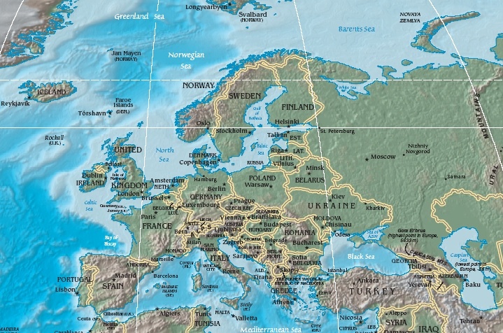
Physical_Map_of_Europe.jpg (719 × 476 billedpunkter, filstørrelse: 185 KB, MIME-type: image/jpeg)
|
|
Denne fil er fra Wikimedia Commons. Beskrivelsen af filen fra Commons er gengivet nedenfor. |
- Extended map (enlarged labels): Image:Europe_terrain_CIA_map_extended.jpg.
Beskrivelse
| Beskrivelse | Terrain map of Europe, as cropping from the CIA's Physical Map of the World. |
| Dato | Map dated April 2008 |
| Kilde |
Cropped section from the CIA's Physical Map of the World, formerly available at: but moved to webpage (March 2009): Those webpage URLs require secure-post ("https"), for access, because those pages are encrypted. The larger image this one was cropped from may or may not still be available. |
| Forfatter | work of U.S. CIA |
| Andre versioner |
Same map in expanded form (more labels):
|
Licensering
This image is in the public domain because it contains materials that originally came from the United States Central Intelligence Agency's World Factbook.
|
 |
Filhistorik
Klik på en dato/tid for at se filen som den så ud på det tidspunkt.
| Dato/tid | Miniaturebillede | Dimensioner | Bruger | Kommentar | |
|---|---|---|---|---|---|
| nuværende | 19. okt. 2005, 13:56 | | 719 × 476 (185 KB) | Grillo | Physical map of Europe. Cropped from http://cia.gov/cia/publications/factbook/reference_maps/pdf/physical_world.pdf and converted to JPG. From en:Image:Physical Map of Europe.jpg {{PD-USGov-CIA-WF}} |
Filanvendelse
De følgende 20 sider bruger denne fil:
- Danmarks geografi
- Europas geografi
- Frankrigs geografi
- Grækenlands geografi
- Hollands geografi
- Irlands geografi
- Liechtensteins geografi
- Monacos geografi
- Norges geografi
- Schweiz' geografi
- Slovakiets geografi
- Sloveniens geografi
- Storbritanniens geografi
- Sveriges geografi
- Tjekkiets geografi
- Tyrkiets geografi
- Tysklands geografi
- Ukraines geografi
- Østrigs geografi
- Skabelon:Europas geografi
Global filanvendelse
Følgende andre wikier anvender denne fil:
- Anvendelser på as.wikipedia.org
- Anvendelser på bat-smg.wikipedia.org
- Anvendelser på bg.wiktionary.org
- Anvendelser på cy.wikipedia.org
- Anvendelser på de.wikipedia.org
- Anvendelser på el.wikipedia.org
- Anvendelser på en.wikipedia.org
- Anvendelser på es.wikipedia.org
- Anvendelser på es.wikibooks.org
- Anvendelser på fr.wikipedia.org
- Anvendelser på id.wikipedia.org
- Anvendelser på it.wikipedia.org
- Anvendelser på ko.wikiquote.org
- Anvendelser på ky.wikipedia.org
- Anvendelser på lrc.wikipedia.org
- Anvendelser på map-bms.wikipedia.org
- Anvendelser på mk.wikipedia.org
- Anvendelser på ml.wikipedia.org
- Anvendelser på nn.wikipedia.org
- Geografi
- Russisk historie
- Tysk historie
- Byar i Sveits
- Jersey
- Irsk historie
- Byar i Tyskland
- Mal:Europeisk geografi
- Albansk geografi
- Andorransk geografi
- Armensk geografi
- Austerriksk geografi
- Aserbajdsjansk geografi
- Belarusisk geografi
- Belgisk geografi
- Bosnisk geografi
- Bulgarsk geografi
- Kroatisk geografi
- Kypriotisk geografi
Vis flere globale anvendelser af denne fil.