
Fil:WW2-Holocaust-Ukraine big legend.PNG
WW2-Holocaust-Ukraine_big_legend.PNG (700 × 342 billedpunkter, filstørrelse: 237 KB, MIME-type: image/png)
|
|
Denne fil er fra Wikimedia Commons. Beskrivelsen af filen fra Commons er gengivet nedenfor. |
Beskrivelse
| Beskrivelse |
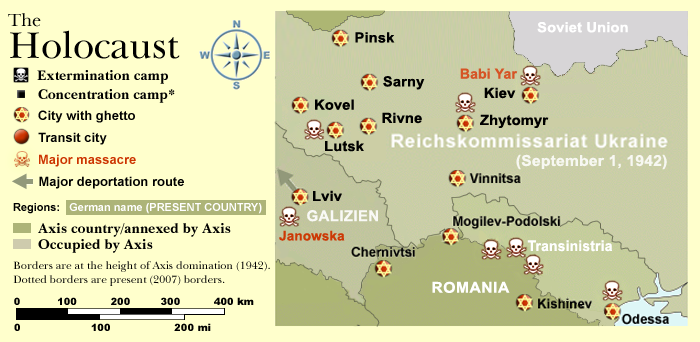
Map of the Holocaust in Ukraine during World War II, 1939-1945. This map shows all extermination camps (or death camps), most major concentration camps, labor camps, prison camps, ghettos, major deportation routes and major massacre sites. Notes: 1. Extermination camps were dedicated death camps, but all camps and ghettos took a toll of many, many lives. 2. Concentration camps include labor camps, prison camps & transit camps. 3. Not all camps & ghettos are shown. 4. Borders are at the height of Axis domination (1942). 5. Some regions have German designations (e.g. "Ostland"), with the present country name denoted in uppercase letters in parenthesis below the German designation (e.g. "(AUSTRIA)"). 6. Present (2007) borders are dotted. Map of the Holocaust in Europe during World War II, 1939-1945. This map shows all extermination camps (or death camps), most major concentration camps, labor camps, prison camps, ghettos, major deportation routes and major massacre sites. Notes: 1. Extermination camps were dedicated death camps, but all camps and ghettos took a toll of many, many lives. 2. Concentration camps include labor camps, prison camps & transit camps. 3. Not all camps & ghettos are shown. 4. Borders are at the height of Axis domination (1942). 5. Some regions have German designations (e.g. "Ostland"), with the present country name denoted in uppercase letters in parenthesis below the German designation (e.g. "(AUSTRIA)"). 6. Present (2007) borders are dotted. |
| Dato | (UTC) |
| Kilde | |
| Forfatter | |
| Tilladelse (Genbrug af denne fil) |
CC, see below. The map is completely unrestricted for any Wikipedia/Wikimedia project. |
| Andre versioner | Derivative works of this file: WW2-Holocaust-Poland.PNGImage:WW2-Holocaust-Europe-2007Borders.png (present (2007) borders). If you have any opinions/suggestions, please contact me here on my talk page. |
|

|
Dette billede (eller alle billederne i denne artikel eller kategori) bør genskabes ved hjælp af vektorgrafik som en SVG-fil. Dette har flere fordele; se Commons:Media for cleanup for mere information. Hvis der eksisterer en SVG-version af dette billede, så vær venlig at lægge den op. Efter en SVG-version er blevet lagt op, så erstat denne skabelon med {{Vector version available|nyt billedes navn.svg}} på denne side.
|
Licensering
- Du må frit:
- at dele – at kopiere, distribuere og overføre værket
- at remixe – at tilpasse værket
- Under følgende vilkår:
- kreditering – Du skal give passende kreditering, angive et link til licensen, og oplyse om der er foretaget ændringer. Du må gøre det på enhver fornuftig måde, men ikke på en måde der antyder at licensgiveren godkender dig eller din anvendelse.
: *WW2-Holocaust-Europe.png: User:Dna-Dennis
|Permission=CC, see below. The map is completely unrestricted for any Wikipedia/Wikimedia project. |other_versions=Derivative works of this file: WW2-Holocaust-Poland.PNGImage:WW2-Holocaust-Europe-2007Borders.png (present (2007) borders). If you have any opinions/suggestions, please contact me here on my talk page. }}
- derivative work: Piotr Konieczny aka Prokonsul Piotrus Talk
|Permission= |other_versions= }}
| Dette er et retoucheret billede, hvilket betyder, at det er blevet digitalt ændret fra sin oprindelige version. Ændringer: Smaller version: occupied Ukraine only. Originalen kan ses her: WW2-Holocaust-Europe.png.
|
Oprindelig oplægningslog
This image is a derivative work of the following images:
- File:WW2-Holocaust-Europe.png licensed with Cc-by-3.0
- 2007-12-20T03:41:38Z Dna-webmaster 1310x1090 (845818 Bytes) new version without "Axis cooperating" in legend
- 2007-12-20T02:00:30Z Dna-webmaster 1310x1090 (844034 Bytes) Now entire West Prussia and Wartheland is included in the Third Reich
- 2007-12-19T16:42:15Z Dna-webmaster 1310x1090 (847461 Bytes) still not Da Vinci, but errors have been corrected (Germany borders West/East), West & East Prussia borders/coloring and Poland General Government corrected borders.
- 2007-12-17T10:46:28Z Dna-webmaster 1310x1090 (844633 Bytes) new map with 1942 borders, not Da Vinci, but here it goes...
- 2007-10-19T13:32:25Z Dna-webmaster 1310x1090 (784727 Bytes) and another update
- 2007-10-19T12:21:52Z Dna-webmaster 1310x1090 (789383 Bytes) quick fix
- 2007-10-19T12:11:07Z Dna-webmaster 1310x1090 (789413 Bytes) {{Information |Description=Map of the Holocaust in Europe during World War II, 1939-1945. This map shows all extermination camps (or ''death camps''), most major concentration camps, work camps, prison camps, ghettos, major
Uploaded with derivativeFX
[[Catego
- derivative work: Piotr Konieczny aka Prokonsul Piotrus Talk
|Permission= |other_versions= }}
| Dette er et retoucheret billede, hvilket betyder, at det er blevet digitalt ændret fra sin oprindelige version. Ændringer: legend from primary map. Originalen kan ses her: WW2-Holocaust-Ukraine.PNG.
|
- Du må frit:
- at dele – at kopiere, distribuere og overføre værket
- at remixe – at tilpasse værket
- Under følgende vilkår:
- kreditering – Du skal give passende kreditering, angive et link til licensen, og oplyse om der er foretaget ændringer. Du må gøre det på enhver fornuftig måde, men ikke på en måde der antyder at licensgiveren godkender dig eller din anvendelse.
Oprindelig oplægningslog
This image is a derivative work of the following images:
- File:WW2-Holocaust-Europe.png licensed with Cc-by-3.0
- 2007-12-20T03:41:38Z Dna-webmaster 1310x1090 (845818 Bytes) new version without "Axis cooperating" in legend
- 2007-12-20T02:00:30Z Dna-webmaster 1310x1090 (844034 Bytes) Now entire West Prussia and Wartheland is included in the Third Reich
- 2007-12-19T16:42:15Z Dna-webmaster 1310x1090 (847461 Bytes) still not Da Vinci, but errors have been corrected (Germany borders West/East), West & East Prussia borders/coloring and Poland General Government corrected borders.
- 2007-12-17T10:46:28Z Dna-webmaster 1310x1090 (844633 Bytes) new map with 1942 borders, not Da Vinci, but here it goes...
- 2007-10-19T13:32:25Z Dna-webmaster 1310x1090 (784727 Bytes) and another update
- 2007-10-19T12:21:52Z Dna-webmaster 1310x1090 (789383 Bytes) quick fix
- 2007-10-19T12:11:07Z Dna-webmaster 1310x1090 (789413 Bytes) {{Information |Description=Map of the Holocaust in Europe during World War II, 1939-1945. This map shows all extermination camps (or ''death camps''), most major concentration camps, work camps, prison camps, ghettos, major
- File:WW2-Holocaust-Ukraine.PNG licensed with Cc-by-3.0
- 2009-02-19T18:43:50Z Piotrus 376x240 (54085 Bytes) {{Information |Description=Map of the Holocaust in Europe during World War II, 1939-1945. This map shows all extermination camps (or ''death camps''), most major concentration camps, labor camps, prison camps, ghettos, major
Uploaded with derivativeFX
[[Category:Ghettos in occup
Filhistorik
Klik på en dato/tid for at se filen som den så ud på det tidspunkt.
| Dato/tid | Miniaturebillede | Dimensioner | Bruger | Kommentar | |
|---|---|---|---|---|---|
| nuværende | 24. jul. 2015, 11:07 | | 700 × 342 (237 KB) | Poeticbent | overhaul, cities added, map area enlarged, borders redefined from official records |
| 4. maj 2013, 23:22 |  | 700 × 371 (118 KB) | Poeticbent | r/m dead space, incl. left-over legend from a different map, i.e. Italy, added July 1941 | |
| 19. feb. 2009, 20:47 |  | 700 × 393 (87 KB) | Piotrus | {{Information |Description=Map of the Holocaust in Europe during World War II, 1939-1945. <br> This map shows all extermination camps (or ''death camps''), most major concentration camps, labor camps, prison camps, ghettos, major deportation routes and ma |
Filanvendelse
Den følgende side bruger denne fil:
Global filanvendelse
Følgende andre wikier anvender denne fil:
- Anvendelser på de.wikipedia.org
- Anvendelser på en.wikipedia.org
- Anvendelser på es.wikipedia.org
- Anvendelser på fr.wikipedia.org
- Anvendelser på he.wikipedia.org
- Anvendelser på it.wikipedia.org
- Anvendelser på ko.wikipedia.org
- Anvendelser på pl.wikipedia.org
- Anvendelser på pt.wikipedia.org
- Anvendelser på ru.wikipedia.org
- Anvendelser på th.wikipedia.org
- Anvendelser på tr.wikipedia.org
- Anvendelser på uk.wikipedia.org
- Anvendelser på vi.wikipedia.org
- Anvendelser på zh.wikipedia.org